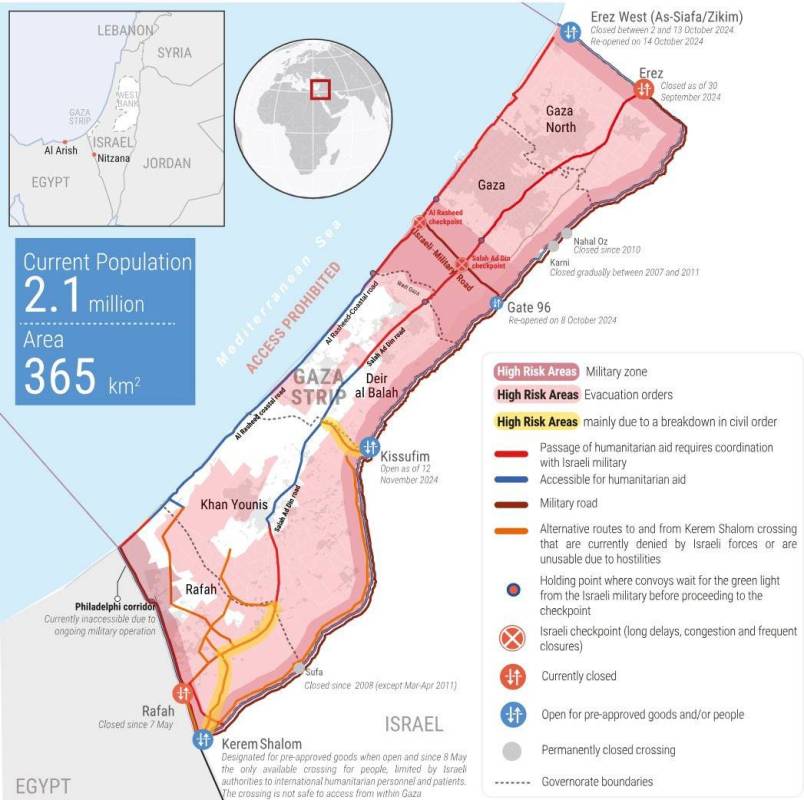
Gaza, MINA – The United Nations Relief and Works Agency for Palestine Refugees in the Near East (UNRWA) Commissioner Philippe Lazzarini published a detailed map depicting the humanitarian disaster in the Gaza Strip, calling for a ceasefire and holding those responsible for the destruction accountable.
Lazzarini posted on X: “80% of the #Gaza Strip is now high-risk areas where people are forced to flee in search for the basics, especially the non-existent safety. They are trapped with no safe place to go. In northern Gaza, people remain under a tight siege. They run for their lives in vicious circles and have been deprived of humanitarian aid for more than 40 days now.”
The UNRWA commissioner wrote: “Across Gaza, the delivery of the little aid allowed in has become overly complex, including because of insecure routes. Civil order has been destroyed. It can be reestablished by #ceasefire + accountability.”
The map attached to Lazzarini’s post is colour-coded, showing high-risk areas divided into military zones, areas with evacuation orders and areas that are high risk mainly due to a breakdown in civil order.
Also Read: 29 Red Crescent Workers Killed in Gaza Amid Ongoing Israeli Attacks
The map also showed areas accessible for humanitarian aid that require coordination with the Israeli army.
In addition, it shows alternative routes to and from Kerem Shalom (Karem Abu Salem) crossing that are currently denied by the Israeli forces or have become unusable due to Israeli attacks.
The map also showed the holding point where aid convoys wait for the green light from the Israeli military before proceeding to the checkpoint. (T/RE1/P2)
Mi’raj News Agency (MINA)
Also Read: Hamas: Testimony from Global Sumud Activists Proves Israeli Brutality
















 Mina Indonesia
 Mina Arabic