
floods
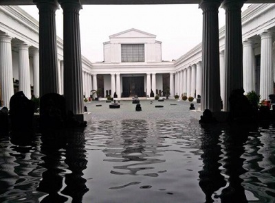
part of the National Museum on Jl. Medan Merdeka Barat, Central Jakarta, on Monday. (Photo: the Jakartapost)" width="300" height="222" /> Water floods part of the National Museum on Jl. Medan Merdeka Barat, Central Jakarta, last year. (Photo: the Jakartapost)Jakarta, 8 Jumadil Awwal 1437/16 February 2016 (MINA) – The Jakarta administration is intensifying efforts to normalize sewage systems in the capital city as the rainy season is forecast to reach its peak in February 2016, Antara News reported.
In early February, floods reaching a height of up to 120 cm inundated 20 neighborhoods in South and East Jakarta municipalities.
“Pumps were used to drain water. Gradually, the floodwaters are receding,” spokesman of the Jakarta Disaster Mitigation Office (BPBD Bambang Suryaputra said February 4.
In East Jakarta, flood-affected areas included Cawang, Kampung Melayu and Bidara Cina, and in South Jakarta it was Pejaten Timur, Pengadegan, Rawajati, Kebon Baru, and Bukit Duri.
Also Read: MUI Warns Government of Risks Behind Proposed Stabilization Force Deployment to Gaza
Following the incessant downpour on February 12, the Ciracas Police Complex was flooded, Jakartas Police reported on its official Twitter account @TMCPoldaMetro in the evening.
Penggilingan Baru and Kampung Pulo areas in East Jakarta were also inundated.
The Jakarta Disaster Mitigation Office (BPBD DKI) has reminded the public that the capital city is currently under the third alert status of flooding.
The water level in several sluices has reached the third alert status at 2:20 a.m. local time on February 13, the office wrote on its official Twitter account @BPBDJakarta.
Also Read: Prof. El-Awaisi: The Mandate to Liberate Al-Aqsa Began at Prophethood
In East Jakarta, flood-affected areas included Cawang, Kampung Melayu and Bidara Cina, and in South Jakarta were Pejaten Timur, Pengadegan, Rawajati, Kebon Baru, and Bukit Duri.
The water level reached a height at 173 cm/MT in Pasar Ikan sluice, 190 cm/MT in Pluit dam, 30 cm/G (alert 4) in Katulampa, and 130 cm/M (alert 4) in Depok, in addition to 790 cm/MT (alert 3) in Manggarai, 510 cm/MT (alert 3) in Kelapa, 160 cm/MT (alert 3) in Krukut Hulu, and 120 cm/MT (alert 4) in Pesanggrahan. It had also reached 145 cm/M (alert 4) in Angke Hulu, 150 cm/M (alert 3) in Cipinang Hulu, 110 cm/T (alert 4) in Sunter Hulu, and 380 cm/T (alert 4) in Pulogadung.
The Jakarta administration is planning to install CCTVs in every pump house across the capital city, aimed at monitoring the water level in every sluice. Of the existing 150 water pump houses, only 12 have CCTVs currently.
The BPBD DKI Jakarta has mapped out that 34 urban villages in Jakarta are categorized as very prone to flooding, and 57 others are in the “prone” category.
Also Read: Mount Semeru Erupts, Trapping Dozens, Forcing Evacuations in East Java
The office has trained 5,000 volunteers in 124 urban villages to help mitigate the impacts of flooding.
The National Disaster Mitigation Agency (BNPB) is currently drafting a contingency plan, as the peak of the rainy season to occur in February might trigger floods, landslides, and whirlwinds.
Floods were expected to occur in the capital city in February 2016, BNPB spokesman Sutopo Purwo Nugroho noted at a press conference on floods and landslides February 10.
Jakarta is on flood alert status from the first until third week of this month and will be on emergency response status in the third and fourth week, according to him.
Also Read: President Prabowo Inaugurates UAE-Funded Emirates–Indonesia Cardiology Hospital in Solo
Currently, the flood alert status covers 18 sub-districts that include 134 neighborhoods in 34 urban villages, with a total of 52,451 people, and 72 shelters for flood victims.
However, in January, the precipitation decreased and was uneven in January this year due to El Nino, he pointed out.
“Due to low precipitation in January 2016, the number of floods and landslides decreased compared to those recorded in January 2105. There was a 43 percent decrease in the number of floods, and a 75 percent drop in the number of landslides that occurred,” he stated.
In the meantime, Jakarta Governor Tjahaja Purnama (Ahok) has urged the World Bank to accelerate the implementation of the Jakarta Emergency Dredging Initiative (JEDI) project aimed at curbing floods in the capital city.
“We have urged the World Bank to accelerate the implementation of the JEDI project, considering that there are 1,058 conduits across Jakartas area,” Ahok stated early this month.
The JEDI project is one of the measures to minimize floods in Jakarta. Its concept is to evenly distribute the flow of water in the city.
“By doing this, floods could be controlled, and the waters would recede faster. Therefore, we want the project to be implemented quickly,” he emphasized.
Jakarta has 13 major rivers, of which the World Bank is in charge of dredging five rivers. The rest will be implemented by the Jakarta provincial administration and the Public Works and Public Housing Ministry.
Also Read: Indonesia’s Hajj Ministry Engages Local MSMEs to Strengthen Catering for 2026 Pilgrims
“Through the Water Planning Service, we constantly dredge every existing water drain, so that every drain is open, and the water can flow smoothly,” he explained.
The JEDI project encompasses seven packages. Package 1 comprises the Ciliwung River, Gunung Sahari, and Melati reservoir (including Kali Gresik and Kali Cideng Hulu rivers). This package is being implemented by the Jakarta administrations Water Planning Service.
Package 2 comprises two sub-packages: 2A Cengkareng Drain and 2B Kali Sunter Hilir River. They are being implemented by the Water Resources Directorate General of the Public Works and Public Housing Ministry.
Package 3 covers the Kali Cideng River in Thamrin, which is also being handled by the directorate general.
Also Read: Indonesia Denies Being Destination for Forced Relocation of Gaza Residents
Package 4 includes the Kali Sentiong Sunter River, North Sunter reservoir, South Sunter reservoir, and East Sunter III reservoir, which is being handled by the Jakarta administration.
Package 5 being implemented by the ministry comprises the rivers of Kali Tunjangan and Kali Angke Bawah.
Package 6 covers the West Flood Canal and Kali Sunter Hulu River and is being carried out by the ministry.
Package 7 covers the Kali Grogol Sekretaris River, Kali Jalekang-Pakin-Kali Besar, and Kali Krukut Cideng rivers, and is being implemented by the Jakarta administration.
Also Read: Indonesian Humanitarian Alliance Urges President Prabowo to Take Role in Sudan Crisis
The project is estimated to cost some US$190 million. Of this amount, the World Bank will contribute about US$140 million, according to information on the World Banks website.
The Government of Indonesia and DKI Jakarta will contribute about US$15.5 million and US$34 million respectively.
A grant worth US$0.5 million from the Netherlands Government will be utilized to help strengthen Jakartas Flood Management Information System.
Indonesia is currently experiencing the peak of the rainy season that has caused flooding and landslides in 166 districts and municipalities in several provinces, including in West Sumatra, North Sumatra, Riau, Bangka Belitung, West, East and Central Java, Jambi, West Kalimantan, and Aceh.(T/R04/R03)
Also Read: Indonesia Welcomes UN Security Council Resolution on Gaza
Mi’raj Islamic News Agency (MINA)
















 Mina Indonesia
 Mina Arabic