


 By: Abdul Shaheed Drew at australia-in-early-muslim-maps-and-literature/" target="_blank">islaminaustralia.com
It is Allah who subjected to you the sea so that ships may sail upon it by His command and that you may seek of His bounty; and perhaps you will be grateful. (The Quran. Al-Jaathiyah. 45:12)
During the eighth and ninth centuries, Muslim trade routes by sea were well established. Busy sea ports could be found from Spain to China. However, sea navigation did not stop at trade. It was also a time of exploration beyond the common shores. The names of many Muslim sailors and explorers have been lost throughout history along with their works. That is why when it comes to old Maps of Australia -or the world- we are limited to a small quantity of those maps and literature today.
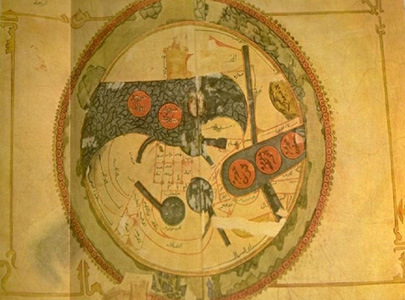
Eric Whitehouse in his book (Australia in Old Maps) presents a ninth century Map from Muhammad Ibn Musa Al-Khuwarizmi. Thought to be the Sea of Java, Whitehouse argues that this map is depicting the north coast of Australia (as opposed to the Sea of Java). Al-Khuwarizmi was instructed by the Caliph (Mamoon) at the time to work with a team of geographers from Dar Al-Hikmah (the House of Wisdom) in Baghdad. Their job was to produce an updated map of the known world. This particular map is one of Al-Khuwarizmis maps which are in the library of Strasbourg University in France. One could not draw a conclusion of what this map really is depicting until the original work is viewed in detail or translated.
Also Read: The Forty-Four-Days of Glory: Azerbaijan’s Struggle for Justice and Peace
Another map of interest presented by Whitehouse is the tenth century map from Abu Is-haq A-Farisi Istakhari. The copy of Istakharis map (page 66) in Whitehouses book looks plausible initially. Deeper investigation into the much clearer and all-inclusive map unearths a possible misinterpretation. The pictures depicting Australia and Japan appear to only be where the paint has come off when the map was folded in half and over time stuck together at certain places (consequently where Australia and Japan are located). Likewise, in the clearer copy, it is obvious that the same particular paint used to depict land mass for other countries on the map is not consistent with what was thought to be illustrations of Australia and Japan.
This does not rule out that Australia was not known of in the ninth or tenth centuries by Muslim navigators. However, if it was known, there definitely was minimal interest at that time for obvious reasons. For example, Sayed Sulaiman Nadwi in his research (The Arab Navigation) makes reference to a sailor known as Abhara of Kirman. This sailor visited China from the Persian Gulf frequently. One account describes Abhara as guiding other ships through the Archipelago safely until they reached a desolate land. From that desolate land they would continue on to China. Nadwi mentions that the desolate land referred to here was probably Australia. (P007/R04)
Mi’raj Islamic News Agency (MINA)
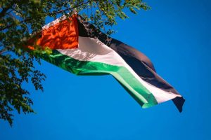
Also Read: Palestine Solidarity Month: A Collective Movement for Al-Aqsa and Palestine’s Freedom


 Mina Indonesia
 Mina Arabic