


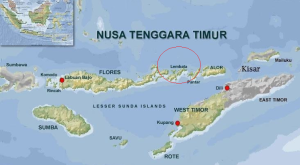
Lembata, MINA – A 5.2-magnitude earthquake struck southeast of Lembata, East Nusa Tenggara (NTT), early Monday morning, April 14, at 2:35 a.m. local time (WIB).
According to Indonesia’s Meteorology, Climatology, and Geophysics Agency (BMKG), the quake’s epicenter was located at 9.12° South and 123.848° East, at a depth of 49 kilometers.
In a post on its official X account, @infoBMKG, the agency confirmed that the quake did not pose a tsunami threat, but urged residents to stay alert in case of aftershocks.
As of now, there have been no reports of damage or casualties.
Also Read: 215 Boats Registered for Riau’s Traditional Boat Race, Nearly Rp500 Million in Prizes
Lembata and the surrounding NTT region sit along a major seismic fault line, where the Indo-Australian and Eurasian tectonic plates meet. This makes the area highly prone to earthquakes caused by plate subduction.
For reference, a similar 5.2-magnitude earthquake struck Borong, East Manggarai Regency, NTT, on February 27, 2025, also linked to tectonic activity in the region.[]
Mi’raj News Agency (MINA)
Also Read: Indonesians in Lebanon Celebrates 80th Independence Day with Festive Celebration at Embassy


 Mina Indonesia
 Mina Arabic