


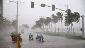
Jakarta, MINA – A warning has been issued by the Meteorology, Climatology and Geophysics Agency (BMKG) regarding high wave situations that have the potential to occur in several water areas on April 20-21 2024.
Based on written information from BMKG on Saturday, the wind pattern in northern Indonesia generally moves from the North East to the East with wind speeds ranging from 4-20 knots.
Meanwhile, in the southern part of Indonesia it generally moves from East-South with wind speeds ranging from 6-30 knots.
The highest wind speed was observed in the waters west of the Nias Islands, waters east of Kep. Mentawai, western waters of West Sumatra, South Indian Ocean, NTB,” he said.
Also Read: Peaceful Muharram: 2 Million Eid Gift Packages to Orphans and Persons with Disabilities
This condition, continued BMKG, causes an increase in waves as high as 1.25-2.5 meters which is likely to occur in the waters north of Sabang, waters west of Aceh-Kep. Mentawai, Enggano-Bengkulu Island waters, western Lampung waters, West Indian Ocean Sumatra Island, western, and southern Sunda Strait, southern waters Java-P. Sumba.
Then also in the southern part of the Bali-Badung-Lombok-Alas Strait, the western part of the Sumba Strait, the Savu Sea, Kupang-P waters. Rote, South Indian Ocean Banten-NTT, eastern Sulawesi Sea, waters of Kep. Sangihe-Kep. Talaud, waters of Kep. Sitaro, northern Maluku Sea, North Pacific Ocean Halmahera, eastern Arafuru Sea
“The potential for high waves in several areas could pose a risk to shipping safety,” he said. (T/RE1/P2)
Mi’raj News Agency (MINA)
Also Read: Responsible Gadget Use Strengthens Healthy Digital Literacy


![MUI Chairman for Foreign Relations and International Cooperation, Sudarnoto Abdul Hakim (center) at the One Million Women for Gaza Press Conference entitled "Women Boycott Pro-Israel Products" held at the Swiss-Belinn Cawang Hotel, East Jakarta, Thursday (3/7/2025). [Photo: Arina/MINA]](https://en.minanews.net/wp-content/uploads/2025/07/20250703_144042-scaled-1-300x225.jpg)


 Mina Indonesia
 Mina Arabic