


Peluncuran kampanye #Kepo Itu Baik# untuk hutan Indonesia
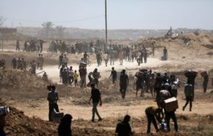
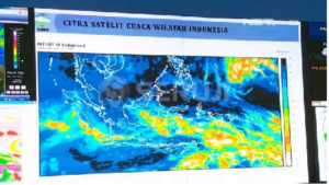
Jakarta, 06 Jumadil Akhir 1437/17 March 20 16 (MINA) – International environmental group Greenpeace on Wednesday launched its self-developed online map, providing real-time monitoring on agricultural fires in Indonesia.
The launch of the map is crucial as Indonesian officials recently detected an increase of hotspots in the country, mostly in Sumatra and Kalimantan islands.
“Greenpeace launches the interactive online map, called ‘Kepo Hutan,’ to support President Joko Widodo’s strong commitment in addressing forest fire,” Greenpeace Indonesia forest campaigner Teguh Surya said in his remarks to launch the interactive map on Wednesday.
The interactive map provides access for the public to get detailed information on concession areas run by plantation firms, peatland, hotspots and forest fire warnings from the authorities, Mi’raj Islamic News Agency (MINA) reported, quoting Xinhua.
Also Read: Peaceful Muharram: 2 Million Eid Gift Packages to Orphans and Persons with Disabilities
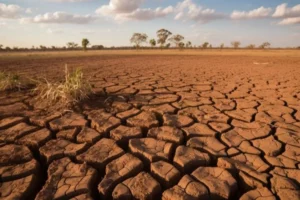
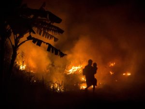
Greenpeace said that Indonesia is now in the recovery process from last year’s deadly wildfire disaster and haze crisis which was caused by slash-and-burn practice, coupled by weather anomaly phenomenon El Nino.
President Widodo has announced series of government plans to protect and recover the peatlands damaged by the fire last year.
Among those plans are legal measures against those implicated in the forest fire and to build canal surrounding the forest areas in case of possible forest fire in the future.
Greenpeace expects that the public will be encouraged to actively partake in monitoring hotspots and taking preventive actions against forest fires.
Also Read: Responsible Gadget Use Strengthens Healthy Digital Literacy
By launching this digital map, the NGO also aimed at pushing the government to issue its One Map Policy, which currently shows no progress.
“This interactive map would divulge many things about Indonesia’s forest management which has yet to be fully transparent. Transparency is highly demanded for an accountable government, (which) can help eradicate corruption. This map would be capable of preventing further losses from corruption in land concession, thus improve the compliance to good forest management practices,” Bambang Widjoyanto, an influential lawyer said at the event in Jakarta.
Indonesia has been suffering from the agricultural fire for a long time. Last year, about 2 million hectares of forest and farmland across the archipelago were devastated by fire, according to data released by the Center for International Forestry Research. (T/R07/R01)
Mi’raj Islamic News Agency (MINA)
Also Read: KMP Tunu Pratama Jaya Sinks, Marking Another Tragedy in the Bali Strait


![MUI Chairman for Foreign Relations and International Cooperation, Sudarnoto Abdul Hakim (center) at the One Million Women for Gaza Press Conference entitled "Women Boycott Pro-Israel Products" held at the Swiss-Belinn Cawang Hotel, East Jakarta, Thursday (3/7/2025). [Photo: Arina/MINA]](https://en.minanews.net/wp-content/uploads/2025/07/20250703_144042-scaled-1-300x225.jpg)

 Mina Indonesia
 Mina Arabic