
Gaza Crisis Atlas
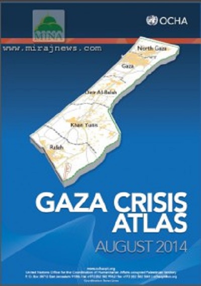
, image of Israeli military aggression to gaza. Photo: Mirajnews.com" width="210" height="300" /> Gaza Crisis Atlas, image of Israeli military aggression to gaza. Photo: Mirajnews.comGaza, 23 Shawwal 1435/19 August 2014 (MINA) – The United Nations (UN) releases a new map about Israeli occupation regime forces attacks on Gaza. Map with satellite image displays damaged houses and public facilities.
The map entitled “Gaza Crisis Atlas” containing 108 pages presents completely damaged homes or hospitals indicated by red dots.
The United Nations Department of Humanitarian Affairs said that the map depicted events during war starting on July 2014. In these maps also explained position of UN’s educational institutions and UNRWA refugee camps.
The maps also shows points of damages in various areas in Gaza Strip. The worst damages appeared in south of Gaza, Gaza City and northern Gaza, mainly near border.
Also Read: Three Palestinians, Including a Woman, Killed in Israeli Airstrike on Rafah
Head of UN’s Commission of inquiry, William Schabas said that the official information from the UN’s was important to facilitate investigation.
Palestine agreed to Egyptian proposal to extend ceasefire for 24 hours starting Tuesday at 0:01 local time, said one of Hamas’ leader, Ezat al Rishq on Monday night in Gaza.
“Egypt asks the extension of ceasefire to give chance to both sides completing or learning points of agreement,” said Rishq broadcasted by Aqsa TV.

Satellite Map Of Khan Younis, South Of Gaza. The red dots are description of damage occurred in gaza. Photo: Mirajnews.com
Meanwhile, a member of Palestinian delegation, Vice Chairman of Hamas Political Bureau, Dr. Mousa Abu Marzouk, said that there has not reached formal agreement yet in indirect talks with Israel mediated by Egypt.
Also Read: Israeli Army Kills 2 Gazans Near Rafah Despite Ceasefire
“We are in front of a confusing situation. If we have reached the agreement we will announce it officially,” said Musa Abu Marzouk.
He reaffirmed that Palestinian delegation would not give up until Israeli occupation regime met all rights of Gaza residents. (L/K01/Syt/E01).
Mi’raj Islamic News Agency (MINA)
Also Read: Palestinian Factions: Balfour Declaration an Unforgivable Crime




















 Mina Indonesia
 Mina Arabic