


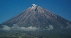
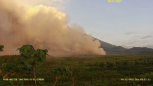
East Java, MINA – Mount Semeru, situated on the border of Lumajang and Malang Regencies in East Java, erupted four times on Sunday morning, with plumes reaching up to 900 meters above its peak.
The first eruption occurred at 12:11 AM WIB, with an ash column observed approximately 400 meters above the summit, or 4,076 meters above sea level (mdpl).
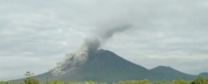
“The ash column was observed to be white to gray with moderate intensity moving southwest. As of this report, the eruption is still ongoing,” stated Liswanto, an official from the Mount Semeru Observation Post, in a written report received in Lumajang on Sunday.
The second eruption took place at 05:17 AM WIB, with the eruption column reaching an estimated 900 meters above the peak, or 4,576 mdpl.
“The ash column was observed to be white to gray with moderate intensity moving south,” he added.
Mount Semeru erupted again at 06:00 AM WIB, with the eruption column observed approximately 700 meters above the peak. The ash column was white to gray with moderate intensity moving south.
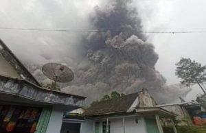
Subsequently, Mount Semeru erupted once more at 08:04 AM WIB, with an ash column observed around 500 meters above the peak (4,176 mdpl). The ash column appeared white to gray with thick intensity moving south and southwest. This eruption was recorded on the seismograph with a maximum amplitude of 22 mm and a duration of 128 seconds.
Also Read: Indonesia’s Hajj Ministry Engages Local MSMEs to Strengthen Catering for 2026 Pilgrims
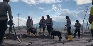
Liswanto explained that Mount Semeru remains at Alert Level II (Waspada). The Center for Volcanology and Geological Hazard Mitigation (PVMBG) has issued several recommendations, advising the public against any activities in the southeast sector, along Besuk Kobokan, within eight kilometers from the peak (eruption center).
The public is also prohibited from engaging in activities within 500 meters of riverbanks along Besuk Kobokan, due to the potential for expansion of hot clouds and lava flows reaching up to 13 kilometers from the summit.
“The public is also urged not to conduct activities within a three-kilometer radius from the crater or summit of Mount Semeru, as it is prone to the danger of incandescent rock projectiles,” he stated.
He further advised the community to remain vigilant for potential hot clouds, lava avalanches, and rain lahars along river or valley flows originating from Mount Semeru’s peak, especially along Besuk Kobokan, Besuk Bang, Besuk Kembar, and Besuk Sat, as well as the potential for lahars in small rivers that are tributaries of Besuk Kobokan. [Shibgho]
Also Read: Indonesia Denies Being Destination for Forced Relocation of Gaza Residents
Mi’raj News Agency (MINA)


 Mina Indonesia
 Mina Arabic