


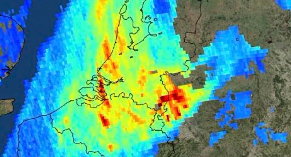


ESA.jpg" alt="" width="600" height="325" class="size-full wp-image-104482" /> Image released by European Space Agency ESA on Friday, Dec. 1, 2017 shows high levels of atmospheric nitrogen dioxide over the Netherlands and the Ruhr area in west Germany taken by Copernicus Sentinel-5P on Nov. 7, 2017 – ESA Photo.
Berlin, MINA -Images taken by a new European satellite show the levels and distribution of air pollutants around the wor ld, including ash spewing from a volcano in Indonesia.
The European Space Agency (ESA) released images on Friday made by its Sentinel-5P satellite that show high concentrations of nitrogen dioxide in parts of Europe on November 22.
Nitrogen dioxide is mainly caused by vehicle emissions and in industrial processes.
High concentrations of the pollutant are seen over parts of the Netherlands, the Ruhr area in western Germany, the Po Valley in Italy and over parts of Spain, BBC reported.
Also Read: US-Israeli War on Iran ‘Close to Over’: Trump
Another image shows pollution drifting away from power plants in India. The worst of this pollution runs from north of Patna, Bihar, to south of Raipur, Chhattisgarh.
High levels of carbon monoxide, commonly produce by fires, in Asia, Africa and South America are also seen. A series of images also show sulphur dioxide, ash and smoke from the Mount Agung volcano in Bali last month.
Sentinel-5P, launched on October 13, can map levels of nitrogen dioxide, methane, carbon monoxide and other pollutants that can be hazardous to human health or contribute to global warming. (T/RS5/RS1)
Mi’raj Islamic News Agency (MINA)
Also Read: Italy Suspends Automatic Renewal of Defense Agreement with Israel: Meloni


 Mina Indonesia
 Mina Arabic